

Climate of India
Indian Climate is a monsoon type, mainly found in South-East Asia and South Asia. Though the Climate of India is a monsoon type, the Indian climate experiences certain regional variations. These include regional variations in precipitation and its amount and temperature-
Regional Variations in Precipitation and its Amount: The Himalayan regions experience snow while other parts of the country experience rain. Jaisalmer (Rajasthan) receives 9cm of Rainfall. At the same time, Mawsynram and Cherrapunji (Meghalaya) receive rainfall over 1080 cm.
Regional Variations in Temperature: Indian Climate experiences a temperature variation. Drass (Ladakh) has a temperature down to -45℃ while at the same time, Chennai experiences a temperature of 20℃ or 22℃. Also, Tawang (Arunachal Pradesh) can have a temperature of 19℃, and Churu (Rajasthan) has a temperature of 50℃ simultaneously.
Despite such variations, the Climate of India is characteristic and rhythmic monsoons. The characteristics of atmospheric conditions and their components reflect the different seasons of a region’s year.
Factors Determining Indian Climate
The Climate of India is the tropical monsoon climate type with regional variations in temperature, precipitation, and amount of rainfall because of the large geographical area. The factors related to relief, location, winds, and air pressure determine India’s Climate. These are explained as under-
- Latitude
The sun rays received by the earth surface is determined by the Latitude. There is a gradual decrease in the temperature from the equator to the poles. Also, India experiences two different types of climates i.e., the Tropical climate and the Subtropical climate. The two climatic conditions is experienced because of the passage of the Tropic of Cancer that divides India into two regions.
- Altitude
On moving from the surface to places with higher altitudes, there is a decrease in the density of the air and temperature. Indian topography includes a variation in the landscapes thus, it experiences a variation in the climatic conditions throughout. Along with this, the weather patterns are also influenced by the presence of huge mountains as these mountains hamper the flow of wind and act as a barrier.
- Pressure and Wind system
It influences the distribution of rainfall and temperature of an area. The significant components of the pressure and wind system include- cyclones, upper air circulation, winds at the surface, and pressure.
- Distance from the Sea and Relief
Sea influences the climate of the coastal areas. There are extreme climatic conditions in the interior land while the climate in the costal areas is moderate.
- The relief also impacts the climate of India. All the physical features that affect the regional climate including temperature. air pressure, wind pressure, speed, and distribution of the rainfall.
Factors related to air pressure and wind
The climate and associated weather conditions in India are governed by the following atmospheric conditions:
1. Distribution of air pressure and winds on the surface of the earth.
2. Upper air circulation caused by factors controlling global weather and the inflow of different airm asses and jet streams.
3. The inflow of western cyclones generally known as disturbances during the winter season andt ropical depression during the southwest monsoon period into India, creating weather conditionsf avourable to rainfall.
Mechanism of weather in the winter season –
1. Surface pressure and winds
a. In winter, the weather conditions over India are greatly influenced by the distribution of pressure in Central and Western Asia. During winter, a high-pressure centre develops in the region lying to the north of the Himalaya
B. This high-pressure area gives rise to the flow of air at the low level from the north towards the Indian subcontinent (south of the Himalayan mountain range).
c. These high-pressure surface winds blow over Central Asia and reach India in the form of a dry continental air mass. These continental winds come in contact with trade winds over north-western India.
d. Occasionally, the contact zone may shift its position as far east as the middle Ganga valley.
e. Thus, the entire region of northwestern and northern India up to the middle Ganga valley comes under the influence of dry northwestern winds.
2. Jet stream and upper air circulation
a. The upper air circulation is dominated by a westerly flow.
b. Western and Central Asia remain under the influence of westerly winds along the altitude 9-13 km (Troposphere) from west to east.
c. These winds blow across the Asian continent at latitudes north of the Himalayas roughly parallel to the Tibetan Highlands.
d. These are known as Jet streams and are located approximately over 27°-30° North latitude, therefore also known as subtropical westerly jet streams.
e. In the winter season, the upper air westerly jet streams are bifurcated into two branches due to physical obstruction of the Himalayas and the Tibetan Plateau.
f. One branch blows to the north of the Tibetan highlands while the southern branch blows in an eastward direction, south of the Himalayas. This southern branch of the jet stream exercises a great influence on the winter weather in India. (Jet Stream – narrow belts of high altitude westerly winds in the troposphere. Their speed varies from about 110 km/hr in summer to about 184 km/hr in winter).
3. Western cyclonic disturbance and tropical cyclones
a. The western cyclonic disturbances are weather phenomena of the winter months brought in by the westerly flow from the Mediterranean region.
b. They usually influence the weather of the north and north-western regions.
c. Tropical cyclones originate over the Bay of Bengal and the Indian Ocean.
d. These disturbances are part of the easterly flow and hit the coastal regions of the country (Tamil Nadu, Andhra Pradesh and Odisha coast).
e. Most of these cyclones are very destructive due to high wind velocity and torrential rains accompanying them.
Mechanism of weather in summer season
1. Surface pressure and winds
a. During the summer season, the sun shifts northwards and the wind circulation over the subcontinent undergoes a complete reversal at the lower as well as upper levels.
b. The Inter-Tropical Convergence Zone (ITCZ), which is the low-pressure belt near the surface, shifts to the north (roughly parallel to the Himalayas between 20°N and 25°N) by them iddle of July.
c. The westerly jet streams also withdraw from the Indian region at about the same time.
d. Meteorologists have found an inter-relationship between the northward shift of the equatorialt rough (ITCZ) and the withdrawal of the westerly jet stream from over the North Indian plain.
E. It is believed that there is a cause and effect relationship between the two. The ITCZ being a zone of low pressure, attracts an inflow of winds from different directions.
f. The maritime Tropical air mass (mT) from the southern hemisphere, after crossing the equator, reaches the low-pressure area in the general south-westerly direction. It is this moist air current that is popularly known as the southwest monsoon.
2. Jet streams and upper air circulation
a. An easterly jet stream flows over the southern part of the peninsula in June and has a maximum speed of 90 km/hr. In August it is confined to 15°N latitude and in September up to 22°N. These easterly jet streams do not extend to the north of 30°N latitude in the upper atmosphere.
3. Easterly jet streams and tropical cyclones
a. The Easterly jet streams steer the tropical depressions into India.
b. These depressions play a significant role in the distribution of monsoon rainfall over the Indian subcontinent.
c. The tracks of these depressions are the areas with the highest rainfall in India.
d. The frequency at which these depressions visit India, their direction and their intensity determine the rainfall pattern during the southwest monsoon period.
Inter Tropical Convergence Zone
The Inter-Tropical Convergence Zone (ITCZ) is a broad trough of low pressure in equatorial latitudes. Here the north-east and south-east trade winds converge and air tends to ascend. This convergence zone lies almost parallel to the equator but moves north or south with the apparent movement of the sun. In July, ITCZ is located around 20°N – 25° N latitude, over the Gangetic plain and is also called the monsoon trough.
This monsoon trough enhances the development of thermal low over north and north-west India. Due to this shift of ITCZ, the trade winds of the Southern Hemisphere cross the equator between 40°E and 60°E longitude and start blowing from south-west to north-east due to the Coriolis force and give rise to the southwest monsoon. The ITCZ moves to the Southern Hemisphere in winter which causes reversal of winds from north-east to south and south-west. These are called north-east monsoons.
- Indian Monsoon
The world is divided into different climatic zones on the basis of different climatic parameters like humidity, precipitation, temperature, etc. Because of the similar climatic pattern in the southeast and southern Asia and India, India is positioned in the monsoonal Climatic region.
- There is an annual seasonal reversal of wind in India. During the summer season, the winds travel from sea to land. In contrast to this, the direction of the wind gets reversed in winter ( it flows from ground to sea).
- The whole of India experiences monsoons with regional variations of rainfall, wind pattern, wetness and dryness degree, and temperature.
- However, one can understand the patterns of monsoon in India by studying it in comparison to the world, especially the monsoon patterns of South Asia are easy to understand.
- In India, the monsoon in winter is northeast while it is southwest during summer.
- The factors responsible for the formation and pattern of the Indian Monsoon are as follows-
Differential heating and cooling of land and water –Because of heat, the land gets heated up much faster as compared to the surface of the sea. The difference in their temperature results in an intense low pressure in the continental areas. This allows the wind to blow in the direction from sea to land and its reverse happens during winters.
- ITCZ – Indian monsoon is highly influenced by the visible movement of ITCZ. During the summer season, the monsoon gets shifted to the north and Ganga plains. This shift creates a Monsoon trough ( intense low pressure) characterized by heavy rainfall.
- During summer, Tibetan plateaus’ intense heating results in the formation of strong vertical air currents with low pressure.
- Jet Streams: The easterly jet streams are present in the peninsular plateau while the western one lies in the north of the Himalayas.
- East of Madagascar, the Southern Indian Ocean’s high-pressure area has a significant influence on the Monsoon in India.
- El NINO/LA NINA – The monsoon winds’ intensity towards Asia is highly affected by the non-continuous change of pressure conditions in the Pacific Ocean.
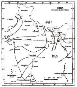
The Onset of Monsoon Affecting Climate of India
In the sub-continent, the low-pressure area is created because of the difference in the water and land heat at the beginning of the summer season. Because of the creation of the low-pressure center, it attracts the Southeast trade winds. Because of the ITCZ presence, the Southeast trade winds cross the Equator. Along with this, the wind is deflected to the east by 40-60 degrees towards the Indian sub-continent which further enters as the South-west monsoon winds in the sub-continent. In June beginning, the monsoon sets over Kerela which further proceeds in the direction inland.
Download www.jkupdate.in Android App
- Monsoon Burst
There is a sudden rise of rainfall at the arrival of the monsoon. This remains the same for a few days. After some time, the pre-monsoon showers appear with the burst in the monsoon. Easterly jet streams cause the monsoon burst.
The monsoon winds in India are divided into two branches in accordance with climate of India: the Arabian Sea branch and the Bay of Bengal Branch. The branch of the Bay of Bengal carries the moisture from the sea and reaches Assam while the one at the Arabian Sea branch moves and stretches to Mumbai by moving through the west coast. The Arabian Sea branch is further divided into the following:
- The western coast is hit by the first branch perpendicularly along Kerala and Karnataka.
- The second branch enters from the Mumbai coast after entering the Ganga Plains, it travels through the mainland crossing of the Chotanagpur Plateau.
- The third branch passes parallelly through the Aravali range after entering the Kachchi peninsula
The Bay of Bengal branch which enters the Indian region from the south and southeast direction (deflected from the east), splits into two branches due to the presence of the Himalayas. One of these branch crosses the plains and enters the Punjab Plains, after this another branch enters the Brahmaputra plains. This branch entering the Brahmaputra results in a huge amount of rainfall in the northeast region. Both of these branches at last meet in the northwestern part of the Ganga plains which experiences a huge amount of rainfall.
Break in Monsoon
In the period of the southwest Monsoon, there will be a break in the rainfall for a few days or weeks. The main reason for this break is the fluctuation of the Monsoon trough (and ITCZ) in the northern part, which reduces the frequency of moisture-laden winds in the mainland. Along with this, the parallel path of winds on the west coast restricts the regional rainfall for a period of a few weeks.
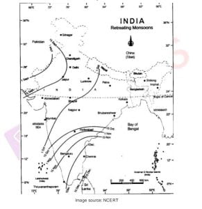
Retreating Monsoon
The Monsoon began to withdraw from the northwestern Indian states by early September and completely by mid-October from the northern half of India and rapidly withdrew from the southern peninsula. At the same time, the Monsoon starts from other parts of the country by early December.
Different Types of Climate in India
The Indian sub-continent has large latitudinal dimensions. Thus, it experiences varying climatic conditions from the north to the south of the country. This includes four seasons based on the climate of India:
Winter Season (the cold weather season)
Summer Season (the hot weather season)
Rainy Season (southwest Monsoon)
The Retreating monsoon season
Winter Season
Cold, dry winds from the north of the Himalayas, especially from central and western Asia, come into contact with the trade winds at the surface over the north and northwestern regions of the country. The Indian weather pattern is greatly influenced by the Jet streams blowing over the upper troposphere. In winter, the Jet streams travels south of the Himalayas over the Ganga plain, and other branch blows north of the Tibetan plateau.
- Jet Streams – The westward wind at the high altitude of the troposphere is called a Jet stream. It has the characteristics of flowing in a meandering path at high speed.
The western cyclonic disturbance is brought by the westerly Jet Stream. It originates in the Mediterranean Sea, and moves towards the Indian northwestern parts. It is characterized by increased night temperatures and brings winter rainfall which aids the cultivation of Rabi crops.
Summer Season
At the beginning of the summer season, the wind gets reversed as atmospheric as well as the surface level. The details of the climate of India have been elaborated herein.
- The Inter-tropical Convergence Zone (ITCZ): The zone where low-pressure troughs at the southeast and northeast part trade winds converge is called Inter-tropical Convergence Zone. Later, the converged wind shifts in the north direction according to the apparent sun movements. It lies parallel and south of the Himalayan region.
The Easterly jetstream flows in the south of the Peninsular region. It navigates the depressions/ tropical cycles into the country.
Rainy Season
Because of the increasing temperature, the low-pressure conditions get intensified over the northwestern plains. By early June, winds of the Southern Hemisphere get attracted by the low pressure. The Monsoon approaches the landmasses into two branches:
- Bay of Bengal branch
- Arabian Sea branch
Retreating Monsoon
The sun moves in the direction of the southern latitudes in September. As a result of this, the Ganga plains’ low-pressure center eventually becomes weak. The weak and low-pressure center is replaced by a high-pressure center. The monsoon from west India gets retreats, and eventually, the low-pressure center is completely eliminated from the land in the month of December. During this period, low pressure is experienced in the Bay of Bengal.
October Heat
The land area experiences a rise in humidity and temperature when the Southwest Monsoon retreats. During this time, the weather becomes oppression. This phenomenon is known as October Heat. The interior of Tamil Nadu along with the Southeast coast experiences heavy rainfall during October and November.
Impact of Global Phenomenon on Indian Monsoon
The Indian monsoon is greatly influenced by the pressure conditions in the southern Pacific Ocean. Usually, there is high pressure in the Southwestern- East Pacific. Along with this, it experiences winds that flow to the South-West Pacific Ocean through this region. The reversal of this condition, i.e., the low pressure in the southeast Pacific Ocean, creates a phenomenon called Southern Oscillation (SO). These are the factors affecting the climate of India-
- El Nino – the cold current is temporarily replaced by El Nini. Also, the frequency varies from 2 to 5 years.
- ENSO (El Nino Southern Oscillation) is a phenomenon in which the pressure changes in the Pacific Ocean are caused by El Nino.
- Indian Ocean Dipole – The phenomenon that is associated with irregular patterns of pressure in the equatorial region in the South of the Indian Ocean.
The phenomenon of the Indian Ocean Dipole is further into the following two categories-
- Positive Indian Ocean Dipole- In this phenomenon, the Western Indian Ocean is the low-pressure area while eastern India experiences the high pressure. As a result of this, the wind gets a shift from Sumatra to Madagascar. An additional push is experienced by the Monsoon winds that tend it to enter Northern Hemisphere. As a result of this push, Indian Sub-continent gets excessive rainfall.
- Negative Indian Ocean Dipole- Madagascar is a high pressure area, the wind in the southern hemisphere (western Indian Ocean) moves to the west of Australia (Eastern Indian Ocean). The movement of wind hampers the South-east trade winds. As a result of this obstruction, the wind entering the North Indian Ocean have low intensity. Eventually, the Indian Sub-continent experiences poor monsoon.